Explore with Our Interactive Map
This GPS-based map shows proposed routes and connections to other trails and transportation hubs. Click here to download segments by town.
The 72-Mile Casco Bay Trail Loop Description
The Casco Bay Trail loop, as currently envisioned, is made up of 15 segments, each of which will have its own evaluation, authorization, design, and construction process. Segments D1-D6 and D7-D8 are rail trails. We have a complementary vision for trains and trails by prioritizing different corridors for each purpose.
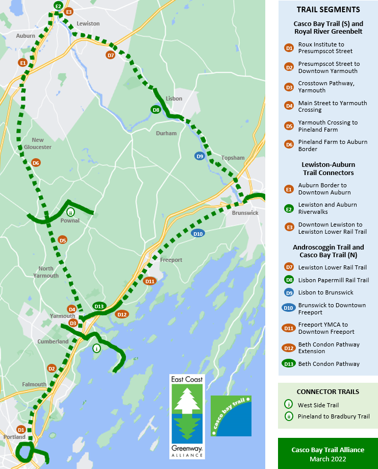
D1. Northeastern University’s Roux Institute to Presumpscot Street
The Casco Bay Trail gateway into downtown Portland is through the planned Northeastern University’s Roux Institute campus in East Deering. The campus plan highlights bicycle and pedestrian access, and prioritizes both a trail loop around the campus, and a trail connector beneath Tukey’s Bridge to the Back Cove Trail, Bayside Trail and Eastern Promenade Trail. The CBTA enthusiastically supports both aspects of this campus vision.

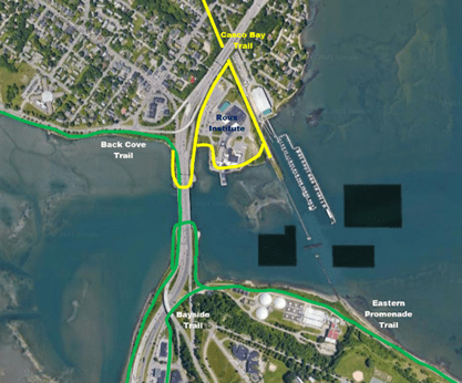
From the waterfront at the planned Northeastern University’s Portland Campus the first 1.2-mile segment of the Casco Bay Trail presents distinct exploratory considerations, first because of the connectivity it offers to the East Deering neighborhood of Portland and the Presumpscot Elementary School, second because of the trail connector possibilities into the planned Northeastern University’s Roux Institute, and third because the Maine Yacht Center uses the rails to transport boats from the marina to its warehouses on Presumpscot Street. A rail-with-trail arrangement would allow for continued transportation of boats along the corridor. Also important to the planning for this segment is the restoration of public access to the full corridor to the shoreline. There is a potentially productive collaboration of interests between the Casco Bay Trail Alliance, Maine Yacht Center, Northeastern University’s Roux Institute, and other abutting property owners, making this segment a high priority for accelerated study of a rail with trail design.
D2. Casco Bay Trail, Portland to Yarmouth
This 8.4-mile segment parallels Route 295, connecting Portland, Falmouth, Cumberland, and Yarmouth. All four of these communities have passed resolutions of support for the Rail Corridor Use Advisory Council process that will evaluate its potential use a rail trail. Key features of this segment include a picturesque bridge over the Presumpscot River, and linkage points with METRO in the East Deering neighborhood of Portland, near Lunt Road in Falmouth, at the Exit 15 Park n’ Ride in Yarmouth, and in downtown Yarmouth.
D3. Royal River Greenbelt, Cleaves St to Main St, Yarmouth
This 0.25-mile segment in Yarmouth is a potential fast-track project, because of its double track, thereby allowing a rail with trail facility to proceed on a faster timetable than required to authorize a rail-to-trail conversion. It is important to the Yarmouth community because it connects Main Street with the existing Cleaves Street trailhead to Yarmouth High School.
D4. Royal River Greenbelt, Main St to Yarmouth Crossing
This 0.8-mile segment in Yarmouth runs from Main Street through Royal River Park, across East Elm Street, past the Yarmouth History Center, and over a picturesque bridge crossing the Royal River. The segment ends at Yarmouth junction, where the SLA corridor crosses the still-active Amtrak corridor.
D5. Royal River Greenbelt, Yarmouth Crossing to Pineland Farm
This 7.0-mile segment runs through the Royal River watershed, connecting Yarmouth, North Yarmouth, Pownal, and New Gloucester. As noted, three of these communities have passed resolutions of support for the Rail Corridor Use Advisory Council process that will evaluate its potential use a rail trail. The route follows the Royal River and near many parks and preserves, including Riverfront Woods Preserve, Chandler Brook Preserve, Baston Park, the Bradbury-to-Pineland Trail, and the Pineland Farm Trail network.

D6. Royal River Greenbelt, Pineland Farm to Auburn Border
This 6.8-mile segment continues to follow the Royal River from New Gloucester to the Auburn border. It is the northern terminus of the state-owned St. Lawrence and Atlantic corridor and, like segment 6, crosses beautiful landscapes and near several parks and preserves, including, Pisgah Hill Preserve, Intervale Preserve, and Thurston Wildlife Marsh.
E1-E3. Auburn and Lewiston Connectors (Route TBD)
The City of Auburn is working to locate a route for the 8-mile segment from Danville Junction to downtown Auburn. It will likely include a trail near the rail corridor through the area of Danville Junction, followed by roadside trails along Station Road and Washington Street to downtown. From there, the trail will connect with the 1.6-mile Lewiston and Auburn Riverwalks, which run along the eastern and western banks of the Androscoggin River, respectively. The ATRC “Bridging the Gaps” plan would then extend the Riverwalk on the Lewiston side for another 0.7 miles toward Lisbon.
D7. Lewiston Lower Rail Trail Project
This 13-mile segment would use the inactive Lewiston Lower Rail corridor. It has been envisioned as a rail trail for 25-years. The corridor is owned by Pan Am and is part of the pending sale of Pan Am assets to CSX. The Lewiston-Auburn Railroad Company and the Androscoggin Land Trust are the groups leading this trail development vision, and an engineering assessment has already been conducted by Sebago Technics. Further negotiations and progress likely await the completion of the CSX purchase of the corridor.
D8. Papermill Rail Trail (Existing Trail)
This 2.1-mile paved rail trail runs along the Sabattus and Androscoggin Rivers and through fields and woods in the town of Lisbon and Lisbon falls.
D9. Lisbon to Topsham-Brunswick (Route TBD)
The state owns the 8-mile rail corridor between Lisbon and Brunswick, but the corridor is still used occasionally for freight transportation. Because it is still an active corridor, discussions about the potential use of this corridor as a rail trail or rail-with-trail have not been initiated to date.
D10. Casco Bay Trail, Topsham-Brunswick to Downtown Freeport (Route TBD)
While no specific route has been identified for this 8-mile segment, introductory meetings have been held with representatives from Freeport and Brunswick, and both communities seem receptive to exploring such a connector trail.
D11. Casco Bay Trail, Down Freeport to Freeport YMCA
The Freeport Active Living Committee is leading a process called Connect Freeport, which among its priority projects, is a multi-use trail on this 4.5-mile segment from the Freeport YMCA to downtown Freeport. The Committee has identified a preliminary routing and is working with property owners and others on the necessary approvals. Also, as part of its headquarters redevelopment project, L.L. Bean negotiated a TIF agreement with the town of Freeport that includes substantial funding for the Concord Brook Trail section on their property. The route through L.L. Bean headquarters and its flagship store is an additional feature of this trail, and its prospective economic development impact.
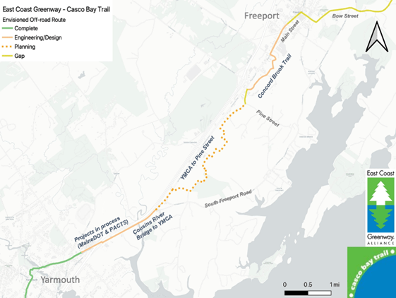
The segment fully connects the downtowns of Freeport and Yarmouth, and with the METRO bus system at multiple locations along the corridor.
D13. Beth Condon Pathway Extension
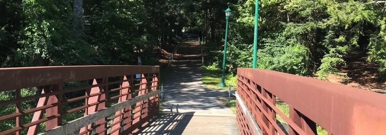
This 1.3-mile segment runs under Route 295 at exit 17 in Yarmouth to the Cousins River, across the Cousins River bridge, and on to the Freeport YMCA. Most of this project is authorized and likely to be completed by 2024. The Exit 17 project has a detailed MaineDOT workplan in process. PACTS has funded a preliminary design report on the continuation segment from there to the Cousins River. The bridge across Cousins River is on the MaineDOT 2024 workplan. Funding still needs to be identified for the remaining distance from the Cousins River to the YMCA.
D14. Beth Condon Pathway (Existing Trail)
This 2.6-mile paved path begins at the intersection of Route 1 and Portland Street in Yarmouth, and continues through the Royal River Park, and on to the Yarmouth-Freeport line. It will soon be extended across the Cousins River to the Freeport YMCA. The southern end of the Beth Condon Pathway connects back to the proposed trail to Portland, described in segments D1-D2, and completing the 72-mile loop.
Download trail segments by town
Curious about where the Casco Bay Trail will run through your town? View and download these PDFs to learn more.
